Aerial Intelligence That Drives Smarter Decisions
We elevate project intelligence through our advanced Drone Surveying, Mapping, Optical Gas Imaging (OGI) and Surveillance Services. By integrating cutting-edge UAV technology with high-precision sensors—including LiDAR, RTK-enabled photogrammetry, thermal imaging, Optical Gas Imaging and surveillance-grade cameras—we provide reliable, real-time data to support decision-making across industrial, environmental and infrastructure sectors.
Our aerial solutions are designed to reduce cost, increase safety and dramatically improve the speed and accuracy of data collection—especially in remote, hazardous or large-scale environments.
Drone LiDAR
Our Drone LiDAR service captures detailed 3D information across large areas—perfect for dense vegetation, steep terrain, and inaccessible sites. This technology enables:
Highly accurate digital terrain and surface models
Volumetric analysis for mining, stockpiles and landfills
Corridor mapping for roads, transmission lines and pipelines
Engineering-grade data for design and construction
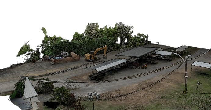
We offer advanced Drone LiDAR (Light Detection and Ranging) Services to deliver highly accurate, high-density 3D point cloud data even in areas where traditional photogrammetry struggles, such as dense vegetation, uneven terrain, or low-light conditions.
Using UAV-mounted LiDAR sensors, we are able to produce detailed, survey-grade topographic models and surface data suitable for engineering, design and environmental applications.
Drone Photogrammetry
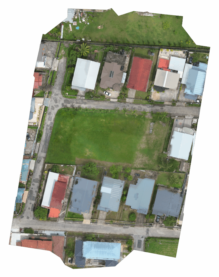
Our Drone Photogrammetry Services provide clients with highly detailed, geo-referenced aerial data that supports accurate planning, design, and analysis. By capturing hundreds of overlapping high-resolution images from above and processing them with advanced photogrammetry software, we generate 2D orthomosaic maps and 3D surface models with centimeter-level precision.
This method is ideal for:
Topographic Mapping
Site Planning & Layout
Construction Progress Monitoring
Land Use & Environmental Studies
Volume Calculations for Stockpiles or Earthworks
Drone Thermal Imaging
At AIMS, our Drone Thermal Imaging Services provide powerful, non-invasive insights that help identify heat anomalies, monitor system performance, and detect potential risks—quickly and safely. Using high-resolution thermal cameras mounted on UAV platforms, we deliver detailed thermal maps and live visuals that support smarter, data-driven decisions in real time.
Thermal imaging is especially valuable for:
Electrical & Mechanical Inspections
Solar Panel Hotspot Detection
Roof & Building Envelope Analysis
Pipeline & Tank Inspections
Firefighting & Search-and-Rescue Support
Environmental Monitoring & Wildlife Management

Drone Optical Gas Imaging (OGI)
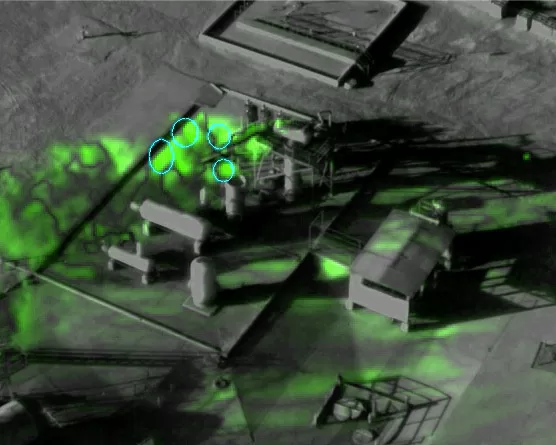
We offer advanced Optical Gas Imaging (OGI) Services to help clients detect and visualize gas leaks that are otherwise invisible to the naked eye. Using state-of-the-art OGI cameras mounted on UAVs or handheld systems, we can quickly and safely identify fugitive emissions of hydrocarbons such as methane, propane, butane and other volatile organic compounds (VOCs).
This non-contact, non-intrusive method allows for real-time detection of gas leaks across complex facilities without interrupting operations—making it ideal for preventive maintenance, regulatory compliance, and environmental safety.
Our OGI services are ideal for:
Oil & Gas Facilities (Onshore & Offshore)
Refineries & Petrochemical Plants
Tank Farms & Pipelines
Compressor Stations & Flare Systems
Environmental Compliance & Leak Detection Programs
Our advanced drone services offer a safer, faster and more cost-effective solution for a wide range of industries. Whether it’s high-resolution LiDAR mapping, detailed photogrammetry, thermal inspections or cutting-edge optical gas imaging (OGI), we provide accurate, actionable data to support better decision-making.
We are committed to harnessing the power of drone technology to deliver precise, reliable results every time. Let us help you elevate your projects from above.