Ground Penetrating Radar Surveying (GPRS)

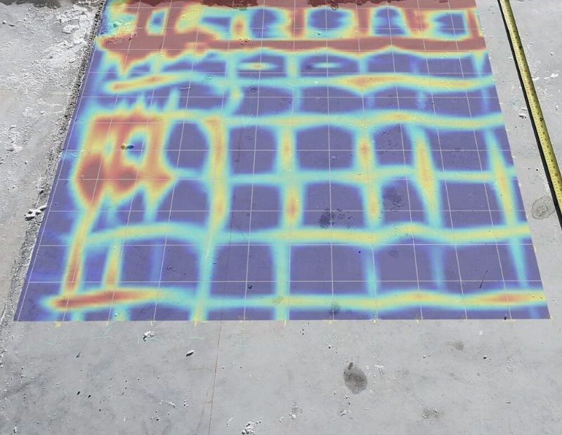
 Ground Penetrating Radar Surveying (GPRS) is a non-invasive way to detect surface and subsurface elements. This versatile method uses electromagnetic pulses to identify void spaces, buried pipes, conduits and other structural elements hidden within the ground. With highly capable equipment, our team has the experience and expertise to handle any GPRS project. 

Drone Surveying & Mapping

 Drone surveying utilizes the technology of aerial drones with cameras and other attachments or payloads to retrieve relevant surveyor data.

 AIMS offers reliable Drone Surveying Services; LiDAR, Thermal and Photogrammetry scanning using the latest and highly advanced drone technology. Our experienced and highly knowledgeable field team are able to plan and execute any drone project with an organized and effective approach.

 Our Drone Surveying and Mapping services can be utilized for a wide array of applications including:

  • Aerial Photography (Photgrammetry, Photo Mosaics & Orthomosaics).
  • Geographic Mapping (Contour Maps, Digital Terrain Models & Digital Elevation Models).
  • Drone Forensics ( Search & Rescue Missions, Developing 3D Models of Crime Scenes).
  • Infrastructure Inspections.
  • Environmental Conservation (Disaster Management, Wildlife Monitoring, Assess Changes in Landscape).

Revit Architecture

 Our team will scan your building structure both inside and outside to develop a dense Point Cloud database. This Point Cloud will then be used by our modeling team to generate a highly accurate Revit Model. Our solution is fast, accurate, cost efficient and our superior service is well known throughout the industry.

Animated Movies

 Using laser scanning technology, accurate 3D models can be created to scale which can then be utilized to simulate movements of components. This has been used to simulate valve removals, changing of components on equipment and even a safety orientation video by showing various muster points and evacuation routes.

Software & Training

 AIMS is a Certified Autodesk Learning Partner and our training facility is a certified Autodesk Training Center as well as an Autodesk Certification Center which is outfitted to train up to 25 students at a time. We offer distance learning by offering remote software installation for the training. Interactive lectures will be done using video conferencing to provide personal support to each student. AutoCAD is one of the world’s leading 2D and 3D CAD design software tool which maximizes productivity by using powerful tools for design and documentation, connecting and streamlining your design and documentation workflows.

 Revit Architecture is a specialized software used to create models of real-world structures and buildings. Revit Architecture is mainly utilized in building information modeling (BIM).

 Our Authorized Training Center is ideal for training small teams and individuals. Some of the training packages include :

Dimensional Control

 Dimensional control surveying is the technique of accurately obtaining measurements of an object in a 3-dimensional space and digitally re-creating it with precisely mapped measurements. These objects can then be analysed against their original design to easily identify inaccuracies.

Stockpiles

 Volumetric analysis can be performed on stockpiles using 3D laser scanning. For large stockpiles of materials, it can be extremely difficult to determine the volume of the material. Using laser scanners to capture the point cloud data of the stockpile, the volume can be determined regardless of size or shape.

Tank Calibration and Inspection

 We offer reliable Tank Calibration and Inspection Services using innovative 3D Laser Scanning technology. This technology provides solutions to quickly capture high accuracy and high density data that is used to evaluate the conditions of tanks. With this data, we are able to locate areas of interest and visualize the entire tank structure as a three-dimensional object. 

 Direct measurements, such as positions and size defects, as well as more detailed analysis of tank roundness and tilt can quickly be generated.  Being able to acquire and easily access this data saves both time and money on projects. Traditionally, this process is done using a survey total station or manual strapping methods; however, these techniques are generally time intensive and are prone to measurement / human errors. 3D laser scanning alleviates these deficiencies by capturing millions of points on average in the same time it takes to capture one point with a total station.

 Our specialized software evaluates the 3D point cloud data captured from inside or outside of a tank, and processes the data according to international codes and standards. All our volumetric strapping tables are generated in compliance with API 650, API 653 and API MPMS Chapter 2.2. By acquiring this data, inspectors are now able to locate areas of interest and visualize the entire tank structure as a three-dimensional object.

2D Engineering Drawings

 With this technology, AIMS has the capacity to produce engineering drawings for facilities in a much-reduced time frame when compared to conventional methods. Accurate detailed drawings can be produced and delivered for the following list:

  • Piping
  • Architectural
  • Structural
  • HVAC
  • Vessels & Equipment
  • Electrical
  • General Arrangements
  • Plumbing
  • P&ID’s
  • Civil

3D Modelling

 Using the industry’s leading software, modelling can be done efficiently and accurately directly from an acquired point cloud using Leica’s Cyclone software. AIMS has modelling technicians in-house to perform tasks at any of these stages, providing  requested models or designs completed by designated deadlines.

Cyclone

 The inherent completeness of 3D point clouds represents one of their major advantages over other sources of geometric information. Cyclone’s unique Object Database Client / Server software architecture provides the highest performance environment for laser scanning projects. Cyclone software makes it easy for users to manage data efficiently in databases. 

 This versatile, powerful module enables professionals to use point clouds directly, to process them into objects for robust import and export into and from CAD (Computer Aided Design) software applications. Cyclone has the industry’s largest and most complete automated set of tools for accurately modelling 3D point clouds as CAD geometry or as meshes for engineering, surveying, construction, architectural and other related functions.

A note to our visitors

This website has updated its privacy policy in compliance with changes to European Union data protection law, for all members globally. We’ve also updated our Privacy Policy to give you more information about your rights and responsibilities with respect to your privacy and personal information. Please read this to review the updates about which cookies we use and what information we collect on our site. By continuing to use this site, you are agreeing to our updated privacy policy.